Last Updated on December 25, 2024 by admin
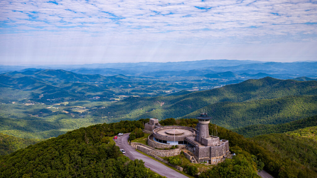
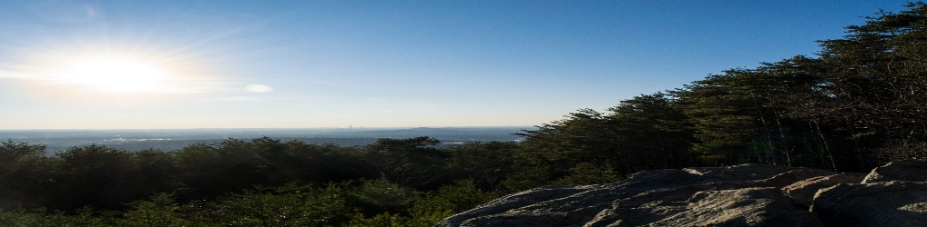
Brasstown Bald
At an elevation of 4,784 feet, Brasstown Bald is the highest elevation in Georgia. Brasstown Bald is apart of the Blue Ridge Mountains (part of the Appalachian Mountains) and is within the border of the Chattahoochee National Forest..
On a clear day, it is possible the see some buildings in Atlanta, approximately 85 miles away.
To be able to do this hike you will have to drive to a parking lot that is about 0.5 miles from the summit. Then you will have the option to either ride the shuttle or to do the hike on a very short paved hiking trail to the top. One thing to note is that if you do the hike, you will be crossing the road that the shuttle runs on.
At the top of the summit there is an observatory where you will also have access to bathrooms as well as park rangers if you visit during business hours.

Rabun Bald
At an elevation of 4,696 feet, Rabun Bald is the 2nd highest elevation in Georgia.While Brasstown Bald is a short hike to the top, the same thing cannot be said of Rabun Bald. The summit is reported to be a 5.8 round trip hike with a stop by the observatory at the top of the summit. That’s right, if you want to reach these heights then you are going to have to earn it.
According to Native American legend, Rabun Bald is the home of fire breathing demon people. It would be interesting to dig into this more.

Dick’s Knob
At an elevation of 4,600 feet, Dick’s Knob is the 3rd highest elevation in Georgia. Much like Brasstown Bald, Dick’s Knob is located in the Chattahoochee National Forest. Dick’s Knob is located in Southern Nantahala Wilderness.
This summit is located very close to the North Carolina border. It is also very close to Grassy Ridge, the 8th highest elevation in Georgia.
Dick’s Knob is not easily accessible through any established hiking trail and care should be taken in trying to reach it.

Hightower Bald
At an elevation of 4,568 feet, Hightower Bald is the 4th highest elevation in Georgia. Just like Rabun Bald, Hightower Bald is located in the Southern Nantahala Wilderness along the North Carolina border.
There are cliffs on the southern face of the mountain.
The summit contains a dwarfed red oak forest.
Unfortunately, no trail passes directly across the summit on Hightower Bald. However, the mountain can be reached by hiking off trail west from the Appalachian Trail at Rich Knob or Bly Gap.
The terrain is pretty steep and the peak is pretty remote.

Wolfpen Ridge
At an elevation of 4,561 feet, Wolfpen Ridge is the 5th highest elevation in Georgia. Wolfpen Ridge is a ridge in the Blue Ridge Mountains.
Brasstown Bald, the highest point in Georgia, is located on the northern ridge while an unnamed peak is located on the southern ridge at a height of 4, 561 feet.

Blood Mountain
At an elevation of 4,458 feet, Blood Mountain is the 6th highest elevation in Georgia. It is also the highest peak on the Georgia section of the Appalachian Trail.
Blood Mountain is a part of the Chattahoochee National Forest and is also a part of the Blood Mountain Wilderness. There are several hiking trails and waterfalls located there.
This hike follows the Appalachian Trail to the summit by the Byron Reece Trail at Neels Gap. There are a lot of great views along the way to the summit at the top.
Despite Blood Mountain being the highest peak on the Georgia section of the Appalachian Trail there are no camp fires allowed while camping. With the popularity of camping on Blood Mountain the frequency of incidents involving bears have gone up in recent years. So proper storage of your food while camping is a must!
Or if you are looking for safer camping options there are also cabins located in the nearby area.

Tray Mountain
At an elevation of 4,430 feet, Tray Mountain is the 7th highest elevation in Georgia. The Appalachian Trail passes over this peak.
Tray Mountain is also a part of the Chattahoochee National Forest and is also a part of the Tray Mountain Wilderness.
Be prepared to drive up a steep gravel road on the wat to the trailhead for Tray Mountain.
To hike the Appalachian Trail from Indian Grave Gap trail across Tray Mountain is about a 5 mile roundtrip hike.

Grassy Ridge
At an elevatioon of 4,400 feet, Grassy Ridge is the 8th highest elevation in Georgia. It is a ridge located in the Blue Ridge Mountains. It stretches from Georgia all of the way into North Carolina.
The Grassy Ridge was burned during a fire in 2016.

Slaughter Mountain
At an elevation of 4,338 feet, Slaughter Mountain is the 9th highest elevation in Georgia. It is the second highest peak in Union County.
Slaughter Mountain is a close neighbor to Blood Mountain. It is named in commemeration of a battle between Cherokee and Creek Indians.

Double Spring Knob
At an elevation of 4,280 feet, Double Spring Knob is tied for the 10th highest elevation in Georgia. The Appalachian trail passes below this peak. The mountain also known as Kelly Knob.
Double Spring Knob is located within the Chattahoochee National Forest.

Coosa Bald
At an elevation of 4,280 feet, Coosa Bald is tied for the 10th highest elevation in Georgia. It is the third highest peak in Union County.
Coosa Bald is located within the Chattahoochee National Forest.
Its peak is crossed by the Duncan Ridge Trail, a trail that connects with the Benton McKaye Trail and the Appalachian Trail.
There we have the 10 highest elevation peaks in Georgia. I have completed some of these hikes and some of them are new to me. It is one of my goals to complete all 10 of these hikes in 2023! Look for future articles about these hikes starting next year. Until then, I am very interested to hear about any hikes that you have made on these hiking trails.
TikTok: Hiking.In.Georgia
Instagram: adventurous.jason
Twitter: @MoreDividends
Facebook: MoreDividendsdotcom